
Printable VFR navigation log
A blank VFR navigation log, free, no account, no email. Print it and fill it in by hand, or let the app fill it in and print that instead.
What is on the sheet
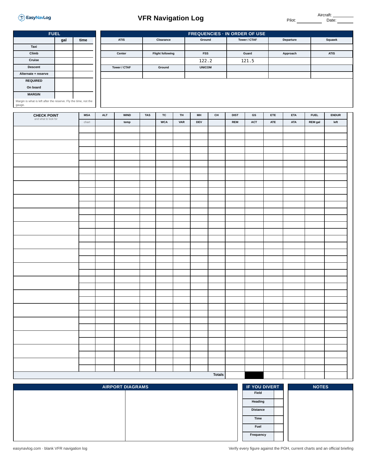
A navigation log is a worksheet for the arithmetic of a cross country. This one has four blocks, and they are in the order you actually use them.
Fuel. Taxi, climb, cruise, descent and your alternate or reserve, in gallons and in time, then what is required against what is on board. The last line is the margin: what is left after the reserve. Fly the time, not the gauge.
Frequencies, in order of use. ATIS, clearance, ground, tower, departure and a squawk across the top; then center, flight following, flight service, guard and approach; then the arrival set. Filling these in the order you will dial them is the whole point, because it means you are never hunting through a chart supplement with the airplane moving.
Checkpoints. One row per leg, and each row is a small wind triangle worked out to a compass heading. Left to right: the checkpoint and what to look for, minimum safe altitude, cruise altitude, the wind, true airspeed, then true course, true heading, magnetic heading and compass heading, then distance, ground speed, time and fuel. The second line of each row is for the corrections: wind correction angle, variation, deviation, and what is remaining.
Airport diagrams, divert and notes. Sketch the departure and destination fields, keep a blank divert block for the day it stops being a hypothetical, and leave room for whatever your instructor says on the ground.
What is on page two
Rows for the briefing: AIRMETs, SIGMETs, convective SIGMETs, PIREPs, TFRs and NOTAMs, in the order a briefer gives them. A station table for the METAR and TAF at departure, destination and anything useful in between. An empty box to sketch the route from the sectional. Fuel broken out by phase of flight. And a blank ICAO flight plan form, which you do not need for a VFR flight but will want the day you file one, and which is worth practising on the ground rather than at the counter.
The order to fill it in
Measure true course off the chart first, then look up the winds aloft and solve for wind correction angle and ground speed. Apply variation to get magnetic heading, then deviation from the compass card to get compass heading. Distance divided by ground speed gives you time; time times fuel burn gives you fuel. Everything else follows from those six numbers.
If any of that is where you get stuck, the column-by-column guide walks the whole form, and the wind triangle guide covers the part most people redo twice.
When a blank sheet is the right tool
Working a navlog by hand is how you learn what the numbers mean, and your instructor is right to make you do it. Print the blank sheet for that, and for the checkride, where you will be expected to show your work.
Where a blank sheet stops earning its keep is the fourth time you fly the same route. Copying the same frequencies out of the chart supplement and interpolating the same winds aloft is not teaching you anything new by then, and it is the part that eats the evening before a flight.
Why this sheet and not your school's
Most flight schools hand out their own navlog with their own column order, and if yours does, that is the form you have to turn in. EasyNavLog builds several school layouts as well as this standard one, and if yours is not in there yet you can send us the form.
Printing it
The PDF is two US Letter pages. Print at 100 percent, not "fit to page", or the column widths will drift. Both pages are designed to be legible in black and white on a knee board, so there is no need to waste colour on them. If you only want the navlog, print page one.